NavTable - gvSIG extension
NavTable is a simple tool that was thought to get a more comfortable user experience in GIS. In spite of beeing a very recent development it is very useful in order to work with data everyday.
The extension NavTable has been developed by the Cartography Engineering Laboratory of University of A Coruña, Cartolab and it's currently maintained by CartoLab and iCarto. It has been released under the terms of the version 3 of the GNU General Public License. We encourage to any user to let us know any suggest, comment, bug reports, etc...
Main Features
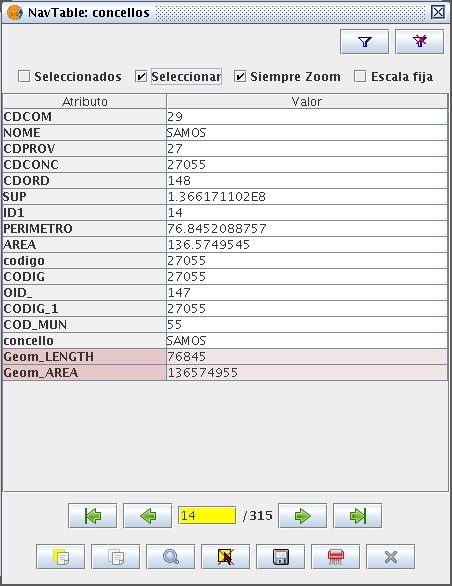
- Visualization of vectorial layers data in records one by one and in vertical direction.
- Direct access to contiguous records, first, last or even to a specifc one. Cursor keys supported
- Allow to select and unselect elements.
- Edition of alphanumeric values on vectorial and alphanumeric tables.
- Direct copy of attributes from other register (from last or the selected record).
- Zoom: automatic and manual to an element, also supports zoom with fixed scale.
- Navigation by means of selection filters.
- Quick filters through the contextual menu.
- Available in English, Galician, Spanish, Portuguese, French and German.
How to use it
In order to use NavTable, first we must select a layer into the gvSIG's TOC and press the button ![]() . This will open the NavTable window and from now on it will be possible to deal with using its buttons and checkboxes.
. This will open the NavTable window and from now on it will be possible to deal with using its buttons and checkboxes.
Read the user manual [EN] - [ES] - [IT] or watch a screencast to learn how to use the main NavTable features:
Downloads
NavTable is an official extension of gvSIG, which means that gvSIG versions from 1.10 and onwards are bundled with it by default. You have not to worry about it.
Anyway, find below the released versions of the project in case you need:
| Version | Date | Installer | Binaries | Source code | gvSIG version |
|---|---|---|---|---|---|
| 1.0.3 | 2014-03-06 | gvspk | Manual installation | ZIP - TAR.GZ | gvSIG 1.12 |
| 1.0 | 2012-07-16 | gvspk | Manual installation | ZIP - TAR.GZ | gvSIG 1.12 |
| 0.8 | 2011-03-28 | BIN - EXE | Manual installation | ZIP - TAR.GZ | gvSIG 1.11 |
| 0.6.2 | 2010-08-12 | BIN - EXE | Manual installation | ZIP - TAR.GZ | gvSIG 1.9 and gvSIG 1.10 |
| 0.6 | 2010-05-19 | BIN - EXE | Manual installation | ZIP - TAR.GZ | gvSIG 1.9 |
| 0.4 | 2009-09-18 | BIN - EXE | Manual installation | ZIP - TAR.GZ | gvSIG 1.1.2 |
| 0.2.2 | 2009-06-02 | BIN - EXE | - | ZIP - TAR.GZ | gvSIG 1.1.2 |
| 0.2 | 2009-05-11 | BIN - EXE | - | ZIP - TAR.GZ | gvSIG 1.1.2 |
Installation
NavTable is an official gvSIG plugin, so if gvSIG is installed in your computer, NavTable should be also there. This instructions are provided mostly for update purposes. From the latest versions NavTable can be installed manually or with the gvSIG plugin manager
gvSIG plugin manager
- Open gvSIG, and go to Tools -> Plugin Manager
- Select install from url, and paste in the box the url of the gvspkg that you find above
- Press Next
- Search in the list NavTable and check the box
- Press Next, and in then Finish
- Close gvSIG, and open it again. NavTable should be updated
Manual installation
If you want to install NavTable manually you can download the binary files for the required version and unzip the folder es.udc.cartolab.gvsig.navtable into [gvSIG_installation_path]/bin/gvSIG/extensiones/. Even if the file has .gvspkg as extension, this is a zip file that can be decompressed.
Remove the old folder before paste the new version
How to participate
NavTable is under continuos development, incorporating new features, fixing bugs, etc. That's why all the suggestions, ideas, comments, bug reports will be welcome.
- e-mail: cartolab (at) udc (punto) es
- Users mailinglist: we listen at several gvSIG users mailinglists.
- Developers mailinglist: navtable-devel.
- Bug reports: bug tracker system.
- Translations: user manual is available in English, Spanish and Italian. Some volunteer?.
- Source code: available at github.
Help us to make NavTable better!
Credits
Copyright (c) CartoLab, 2009-2014. Copyright (c) iCarto, 2011-2014.License GNU GPL v3. You can find the terms of this license in http://www.gnu.org/licenses/
CartoLab is managed by: Fco. Alberto Varela García.
Development team (in order of appearance):
- Juan Ignacio Varela García
- Pablo Sanxiao Roca (iCarto)
- Javier Estévez Valiñas
- Francisco Puga Alonso (CartoLab)
- Andrés Maneiro (iCarto)
- Jorge López (CartoLab)
Contributors:
- Francisco Alberto Varela García
- Daniel Díaz Grandío
- Gonzalo Martinez Crespo
- Adrián Eiris Torres
- Jorge Ocampo
- Carmen Molejón
- Vanessa Ros
Special thanks to:
- Francisco José Peñarrubia (Valencia)
- Joaquim Rocha
- Artur Juen
- Silvio Grosso
- Antonio Falciano
- Nacho Brodin
- Benjamin Ducke
- Agustín Diez Castillo
- Jordi Torres
- Giuliano Ramat
- José Antonio Canalejo
Translations:
- Spanish, Galician, English: CartoLab
- French: Gonzalo Martinez Crespo
- Portuguese: Joaquim Rocha
- German: Artur Juen
- Italian: Silvio Grosso and Antonio Falciano
 Last Review: March, 2014.